A new study published in Communications Earth & Environment has shed light on the mystery of why the largest field of pyramids in Egypt is located several kilometers away from the Nile River. The study suggests that when the pyramids were built, they were situated next to a now-vanished branch of the Nile, which likely provided transportation for workers and materials.
The Nile River has changed over time due to climate change, floods, and droughts. As a result, civilizations and their settlements have moved with the river. By examining the landscape in Egypt, researchers have been able to uncover traces of the former river and its branches hidden beneath the land surface.
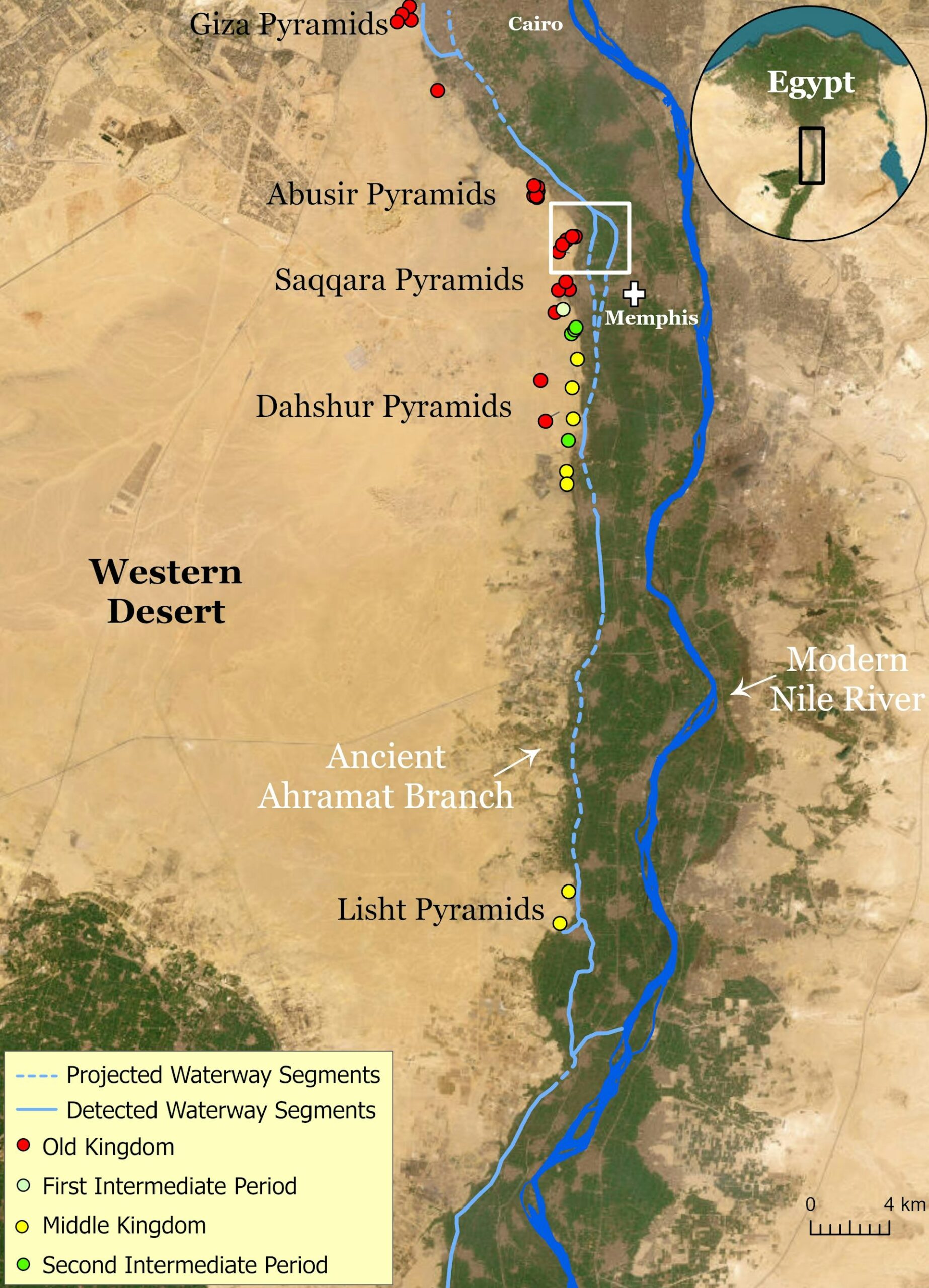
Previous research has provided evidence for the existence of ancient waterways and wetlands near the Giza pyramids. However, until now, there has not been a comprehensive map and understanding of the waterways that fed the extensive pyramid chain from Lisht to Giza in the past.
Using satellite imagery, high-resolution digital elevation data, and historical maps, researchers identified and traced the path of a previously unknown channel of the Nile called the Ahramat Branch. This branch once flowed along the Western Desert margin of the Nile floodplain, near the ancient pyramids.
Many of the pyramids built during the Old Kingdom and Middle Kingdom have causeways that lead to the Ahramat Branch. This suggests that the branch was active during multiple phases of pyramid construction and was likely used as a transportation waterway for workers and building materials.
The research also involved surveying the landscape, taking deep core samples of soil and sediment, and working with archaeologists, scientists, and local communities to gather more context for the study. The Ahramat Branch was found to have run for about 64 kilometers, with a depth between two and eight meters and a width between 200 and 700 meters.
Over time, the Ahramat Branch moved eastward and eventually water stopped flowing along it. The exact reasons for this are still unknown, but possibilities include the river gradually moving to a lower-lying floodplain, tectonic activity tilting the floodplain, or an increase in windblown sand filling up the river’s channel.
This research highlights the need for a multidisciplinary approach to river science in order to better understand dynamic river landscapes. It also emphasizes the importance of understanding and protecting rivers and the culturally significant sites connected to them.